|
Introduction: Brazil is the largest producer and exporter of sugarcane products in the world, and the state of São Paulo has been responsible for nearly half of the national production in the latest years. Among the state's regions, the northeastern portion, which comprises 125 municipalities, is known as the main sugarcane center in the country. Along the last decades, the land-use and cover dynamics at the region has been exposed to significant changes. Despite the fact that there are nearly no untouched areas to be opened, projections made by studies for 2030 show that the region will not remain the same. Expressive production areas, such as citrus, coffee and grain areas, will continue to lose space for sugarcane and it is expected an improvement in land-use efficiency. The environmental impacts of sugarcane expansion and intensification have not been sufficiently studied yet, especially when it comes to their agronomic sustainability in terms of the maintenance of physical, chemical and biological soil attributes. The CarbCana project focuses on the land-use and cover changes at the northeast region of the state of São Paulo along the last ten years and on the consequent change in carbon stock and climate variables that influence air temperature. The study is supplemented by territorial approaches based on remote sensing and on geoprocessing techniques, with the aim of detecting the land-use dynamics and of associating them to the spatial-temporal dynamics of the carbon imprisoned by the agricultural ecosystem's phytomass and soil, as well as of the air temperature.
Leader: Carlos César Ronquim
Institutions involved:
- Empresa Brasileira de Pesquisa Agropecuária (Embrapa),
- Instituto Nacional de Pesquisas Espaciais (INPE),
- Universidade Estadual Paulista (UNESP Jaboticabal),
- Agência Paulista de Tecnologia dos Agronegócios (APTA),
- Centro de Tecnologia Canavieira (CTC),
- Coordenadoria de Assistência Técnica Integral de São Paulo (CATI),
- Universidade Federal de São Carlos (UFSCar).
Abstract: The national and international demand for ethanol and the increasing concerns with world climatic changes is generating the expectation of an increase in the use of biofuels and consequently an increase in the area planted with sugarcane in Brazil, particularly in the northeast part of the state of Sao Paulo where 50% of this crop is located and lately exposed to significant changes in land use. Embrapa is searching for information on how much the Brazilian agriculture can be affected by or can contribute to the worsening of global climatic changes in the future. The CarbCana project provide territorial approaches based on remote sensing and geo-technological techniques associating land use and land cover dynamics with carbon stocks and microclimatic variations. The objective is to map the changes in land use and land cover in the northeast part of Sao Paulo state during the 2003-2013 period and estimate carbon stocks in soil and biomass. In addition, project evaluate changes in air temperature due to evapotranspiration caused by changes in land use, from pasture to citrus, coffee, annual grain crops to sugarcane in different cropping systems like harvesting after burning or not. The project is updating land use and land cover information in the area and evaluating on how these changes are affecting global climatic changes. The results make possible to create environmental indicators and provide more effective subsidies to be used during commodities negotiations. In addition, the project results generate positive impacts on the valorization of agricultural production systems regarding to environmental aspects.
Study Area: The northeast region of São Paulo state, comprising the micro regions of Ribeirão Preto, Araraquara, Barretos, Batatais, Franca, Ituverava, Jaboticabal, São Carlos, São João da Boa Vista, São Joaquim da Barra, Pirassununga and part of the micro regions of Amparo, Limeira, Moji-Mirim, Rio Claro e São José do Rio Preto (Figure 1).
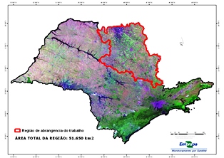
Figure 1.
Objectives: The project's objective is to map land-use and cover changes at the northeast region of the state of São Paulo from 2003 to 2013, and to concurrently estimate the changes in carbon stock and biomass, as well as changes in air temperature which derive from the evapotranspiration. The study encompasses areas where pastures, citrus crops, coffee crops and other annual grain crops have been converted to sugarcane, which is harvested both with burning and with no burning.
Results: The project aims to produce zonings and scientific methods which will contribute to a better understanding of the carbon process, either sequestration or additional emissions in the agricultural ecosystems, and identify the best crop management options to amplify the atmospheric CO2 storage potential and thus further contribute to the mitigation of the greenhouse effect. The results enable creating environmental indicators and more effective subsidies to place the country ahead of others in commodities' negotiations, and generating positive impacts on the environmental valuation of agricultural production systems.
|